Jomolhari Trek Bhutan - To the 'Bride of Bhutan' (7,326m)
Jomolhari Trek at a Glance
The Jomolhari Trek: Bhutan's Most Popular Multi-Day Trek
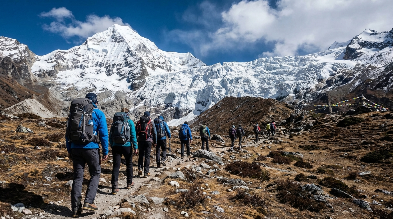
The Jomolhari Trek is considered the equivalent to the Everest Base Camp Trek – only more remote, more pristine, and with considerably fewer visitors. Those who complete this trek wander through Bhutan's largest protected area, the Jigme Dorji National Park, and experience landscapes of overwhelming beauty. From dense pine forests over vast yak meadows to glacier regions: each day brings new impressions.
The Mountain Jomolhari – The "Bride of Bhutan"
At 7,326 meters, Jomolhari is one of the highest peaks in Bhutan. The Bhutanese affectionately call it the "Bride of Bhutan". Flanked by the 6,989-meter-high Jichu Drake, whose elegant pyramid shape completes the panorama. Unlike in neighboring Nepal, the ascent of these peaks is forbidden: they are considered sacred mountains and the abode of gods. For trekkers, this means experiencing the mountain in its untouched majesty – a privilege that makes this expedition particularly special.
What Makes This Trek Special?
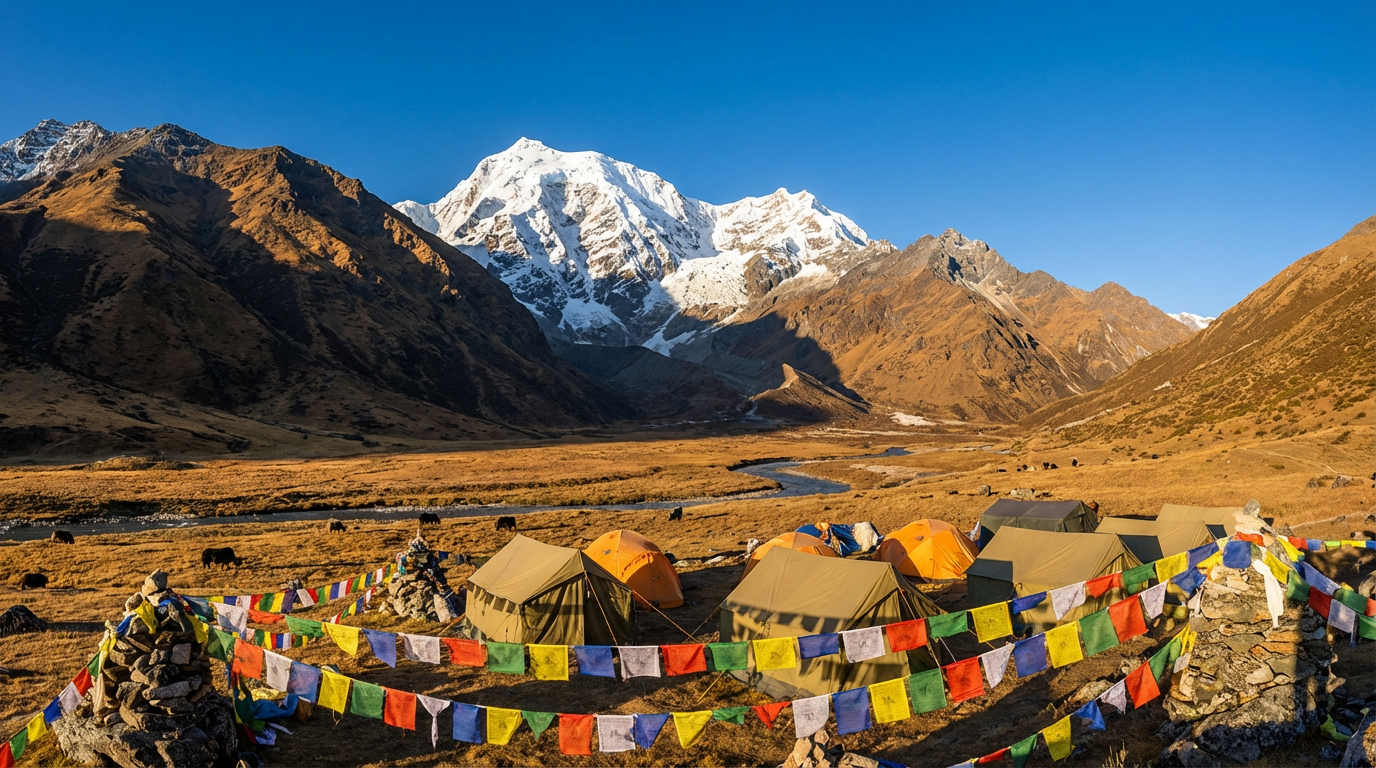
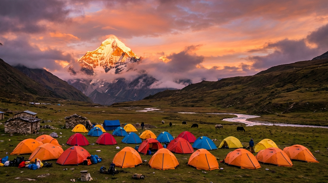
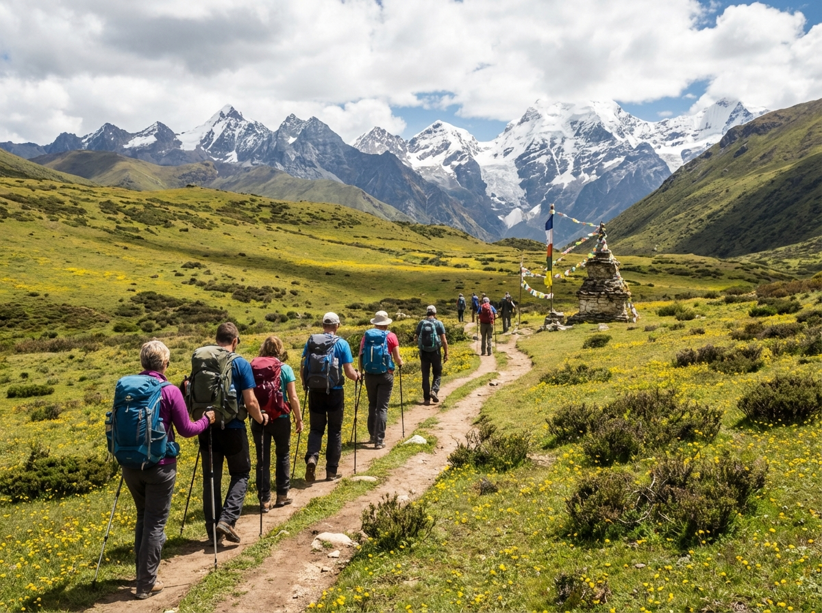
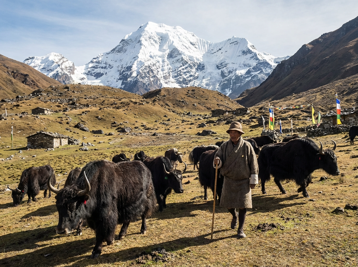
The Jomolhari Trek combines spectacular natural experiences with cultural encounters. You hike along glacier streams, pass crystal-clear mountain lakes, and meet yak herders who have lived in this remote region for generations. The highlight: nights at the Jangothang Base Camp at 4,080 meters, where the historic ruins of an old fortress frame the view of the Jomolhari's ice wall. Add to this a diverse flora and fauna – from blue sheep to rare Himalayan bird species.
Elevation Profile and Route of the Jomolhari Trek
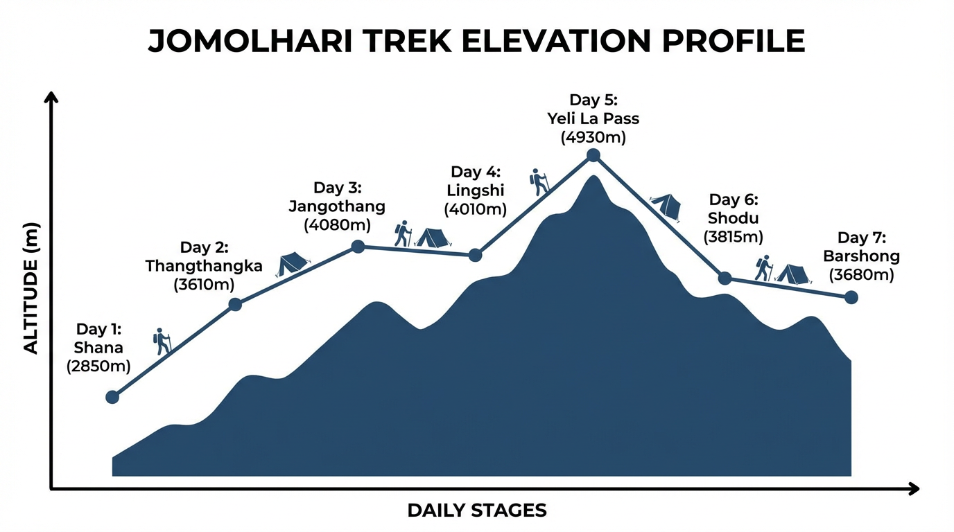
The trek begins at Drukgyel Dzong near Paro at about 2,850 meters and takes you to almost 5,000 meters elevation. This elevation gain of over 2,000 meters is one of the greatest challenges – and at the same time the reason for the fascinating diversity of landscapes. You traverse different vegetation zones: from shady pine forests over open yak pastures to the sparse but impressive glacier region.
Key Elevation Data
| Point | Elevation | Significance |
|---|---|---|
| Starting Point Shana/Drukgyel | approx. 2,850 m | Trek start near Paro |
| Jangothang Base Camp | 4,080 m | Legendary base camp with Jomolhari panorama |
| Nyile La Pass | 4,820 m | First high pass on the route |
| Yeli La Pass | 4,930 m | Highest point of the entire trek |
Landscape Zones Along the Route
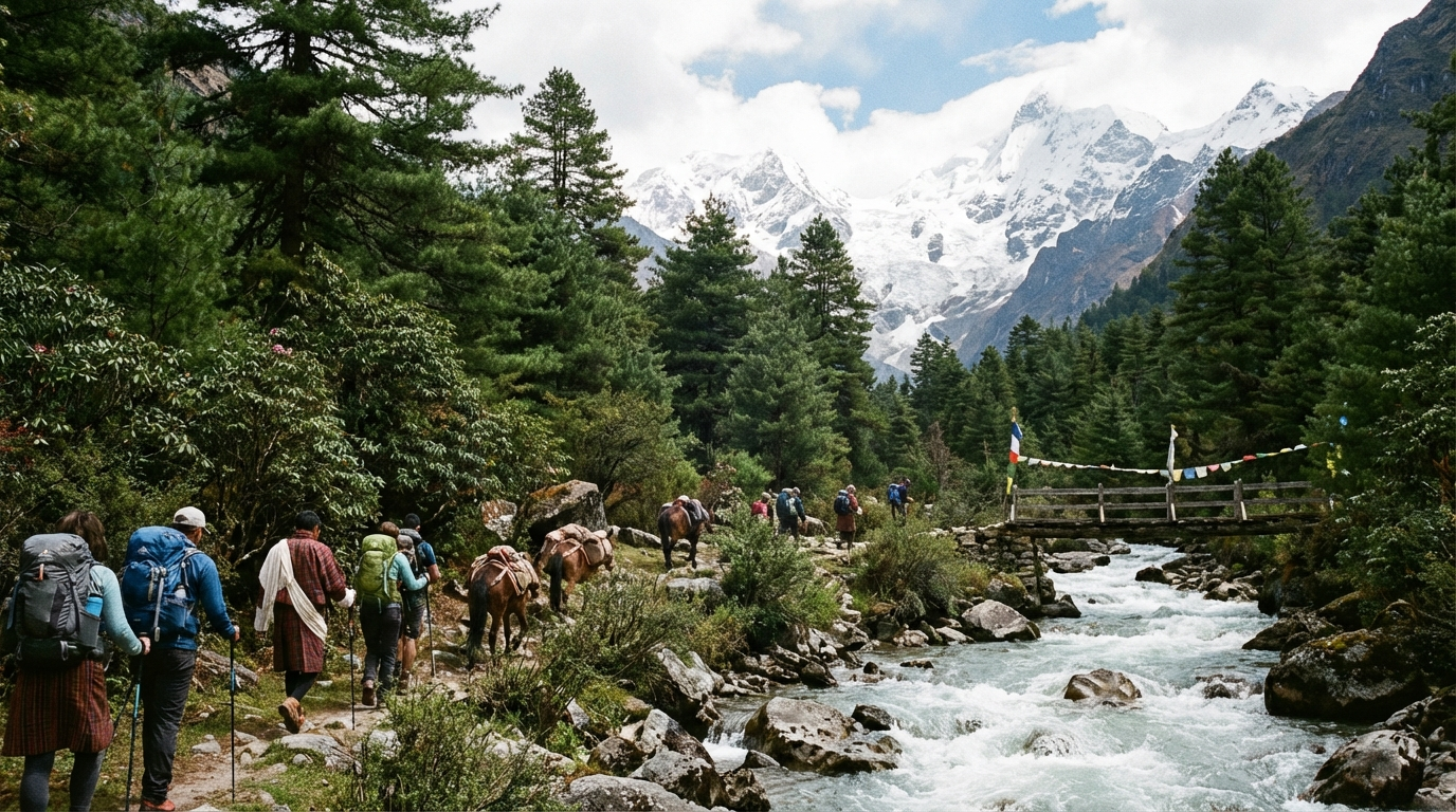
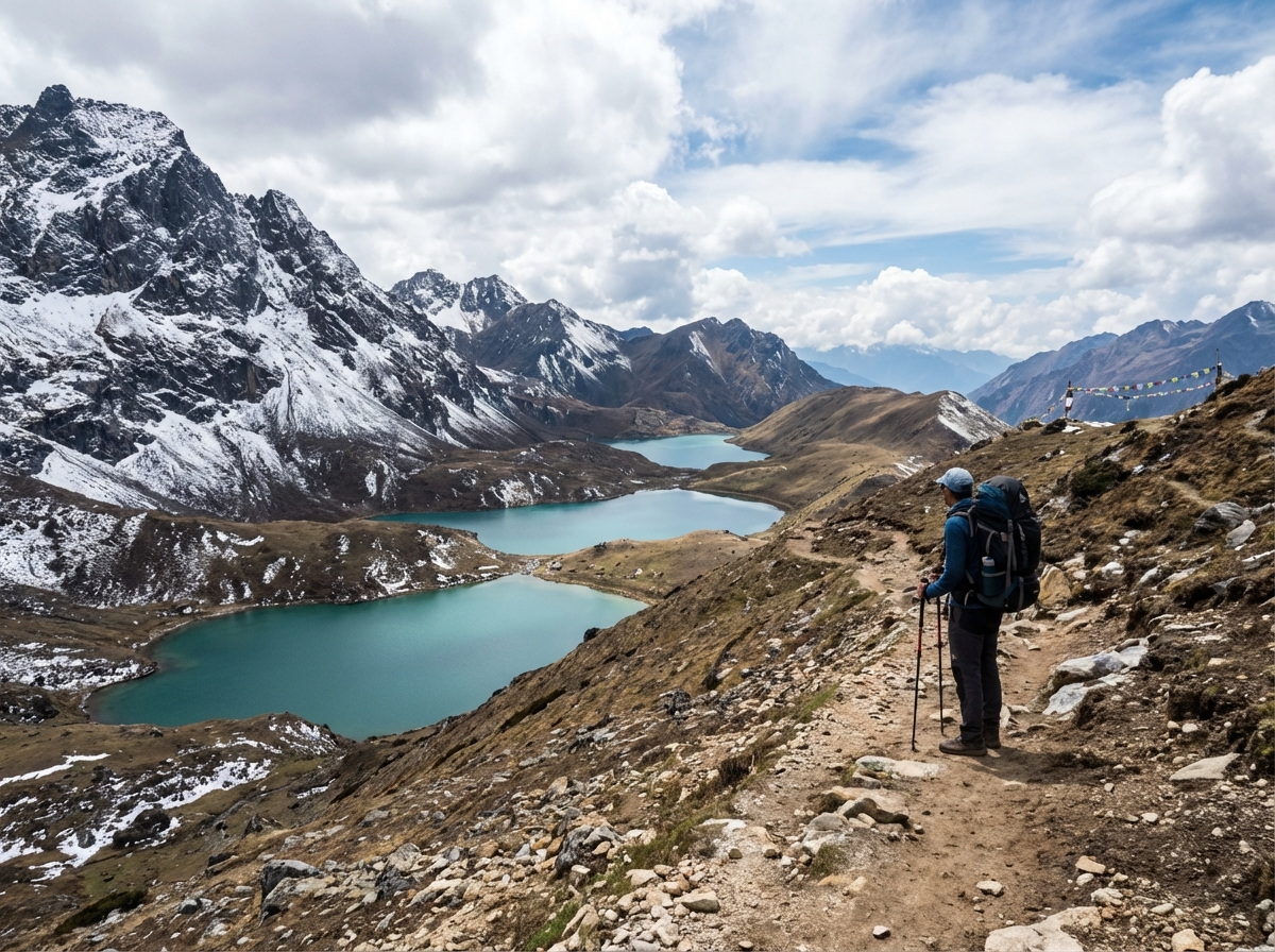
The route passes through three distinct zones: in the lower zone you hike through dense pine and juniper forests, crossed by rushing mountain streams. From about 3,500 meters the landscape opens into vast yak pastures where you encounter herders with their herds. Above 4,000 meters you enter the glacier region with its alpine vegetation, crystal-clear lakes, and spectacular views of the ice giants of the Himalayas.
Difficulty Grade: Is the Jomolhari Trek Right for Me?
The Tourism Council of Bhutan rates the Jomolhari Trek as "moderate to challenging". This assessment is realistic: the trek is suited for experienced hikers with good fitness. Prior altitude experience is not a strict requirement, but definitely an advantage. If you've already been hiking in the Alps above 3,000 meters, you have a good foundation.
Daily Requirements
- Walking time: 5–8 hours per day, depending on the stage
- Terrain: Steep ascents on narrow, winding paths
- Technique: No climbing required, but you should be sure-footed
- Distances: Daily stages up to 22 kilometers
The Greatest Challenges
Fitness Requirements
For the Jomolhari Trek you need very good basic fitness. You should be able to hike 6–8 hours per day without problems, even with a backpack and in rugged terrain. Equally important is mental strength: long days in changeable weather require perseverance. Ideally, you already have experience with high-altitude hikes.
Jomolhari Trek Itinerary: The Classic Route
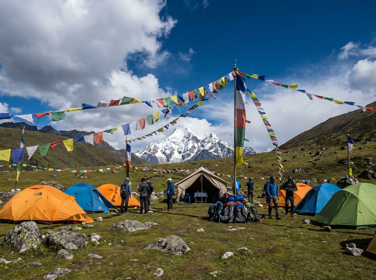
The classic Jomolhari Trek takes 7–9 days and leads from Paro to Thimphu. Depending on fitness and weather, the itinerary can be adjusted. Here we describe the standard route with an important rest day for acclimatization at Jangothang Base Camp. Note: the distances are long, but your gear will be carried by pack horses or yaks.
Day 1: Paro – Shana – Thang Thangkha (22 km, 7–8 h)
After the drive from Paro to the starting point at Shana, the adventure begins. The first stage leads along the rushing Paro Chhu through dense pine forest. It is the longest daily stage of the entire trek – a deliberately challenging start that prepares you for the coming days. The camp at 3,610 meters offers first glimpses of the mountains awaiting you.
- Distance: 22 km
- Walking time: 7–8 hours
- Elevation gain to: 3,610 m
- Highlights: Paro Chhu river valley, pine forests, first Himalaya views
Day 2: Thang Thangkha – Jangothang Base Camp (19 km, 5–6 h)
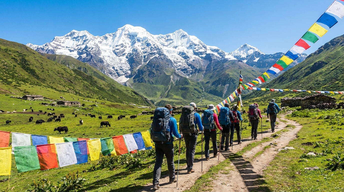
The day of the big moment: for the first time the Jomolhari appears before you – a sight that takes your breath away. The landscape opens, forests give way to yak pastures. In the afternoon you reach Jangothang, the "land of ruins". Here stand the remains of an old fortress, behind it rises the mighty ice wall of the Jomolhari, flanked by the elegant Jichu Drake.
- Distance: 19 km
- Walking time: 5–6 hours
- Elevation gain to: 4,080 m
- Highlights: First Jomolhari sighting, arrival at legendary base camp
Day 3: Rest Day in Jangothang – Acclimatization
This day is essential for your altitude adjustment – and a gift to all your senses. Use the time for optional explorations: the hike to the Jomolhari Glacier takes about 4–5 hours and takes you to the base of the mighty ice wall. Alternatively, the Jichu Drake Glacier (3 hours) beckons or an ambitious peak tour to 5,200 meters for a 360-degree panorama. Or simply enjoy the silence and watch the interplay of light and shadow on the mountains.
- Activity: Acclimatization and optional explorations
- Camp elevation: 4,080 m
- Options: Glacier hikes, photography, rest and relaxation
Day 4: Jangothang – Lingshi (18 km, 6–7 h)
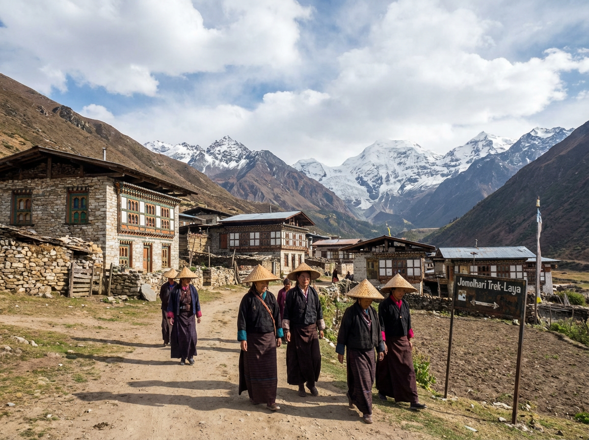
Today marks the first major pass crossing: the Nyile La at 4,820 meters rewards you with spectacular views of the surrounding peaks. The descent to Lingshi leads through alpine landscapes where you meet yak herders who spend summers here. The camp lies at 4,010 meters in a wide valley basin.
- Distance: 18 km
- Walking time: 6–7 hours
- Highest point: Nyile La Pass, 4,820 m
- Camp elevation: 4,010 m
Day 5: Lingshi – Shodu (22 km, 8–9 h)
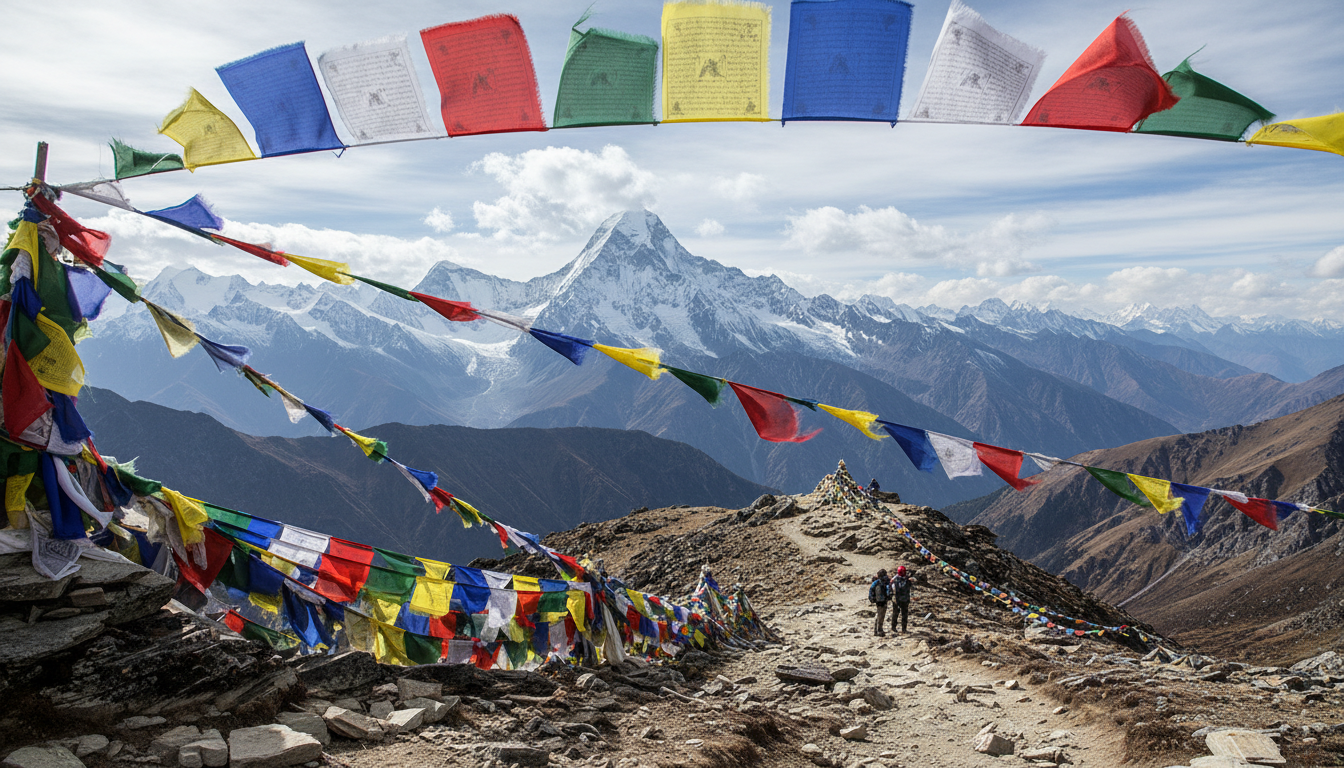
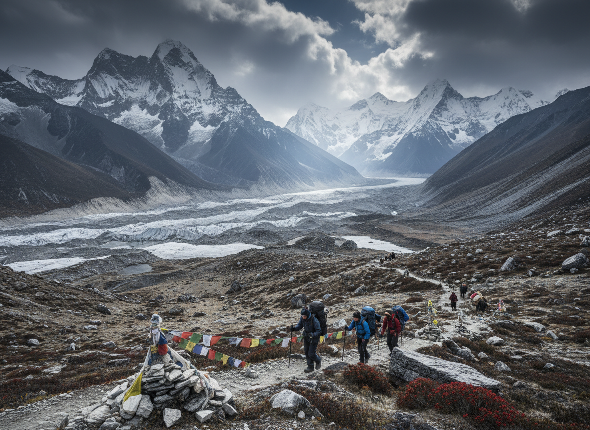
The king's stage of the trek: at 22 kilometers and crossing the Yeli La at 4,930 meters, this is the longest and most challenging day. The ascent to the highest point of the entire trek requires endurance – but the panorama at the pass rewards every effort. Prayer flags flutter in the wind while the mountain panorama stretches in all directions.
- Distance: 22 km
- Walking time: 8–9 hours
- Highest point: Yeli La Pass, 4,930 m – highest point of the trek
- Camp elevation: 4,080 m
Day 6: Shodu – Barshong (16 km, 5–6 h)
After the strenuous previous day, a more relaxed stage follows. The path leads downhill through changing vegetation – you feel how the air becomes denser with each meter of altitude. Forests reappear along the way, temperatures rise. The camp at 3,710 meters marks the transition back to lower, warmer regions.
- Distance: 16 km
- Walking time: 5–6 hours
- Descent to: 3,710 m
- Character: Relaxing descent through changing landscapes
Day 7: Barshong – Dodena/Thimphu (15 km, 4–5 h)
The last trekking day takes you back to civilization. In Dodena the trek ends, a transfer brings you to Thimphu. Returning to the capital after a week in the wilderness feels almost unreal. We recommend at least one night in Thimphu for recovery – and to process the impressions before continuing your journey.
- Distance: 15 km
- Walking time: 4–5 hours
- End: Dodena, followed by transfer to Thimphu
Jomolhari Trek Variants: Which Route is Right for Me?
There are various ways to experience the Jomolhari – depending on available time and personal preferences. The short version takes you to the base camp and back in a few days, while the extended route includes additional exploration days and a visit to the remote Laya village.
 Compact
 Jomolhari Loop (4–5 Days)
To the base camp and back on the same route. You experience the same highlights – Jangothang, the Jomolhari view, encounters with yak herders – in compact form. Ideal with limited time budget.
 Recommended
 Classic Trek (7–9 Days)
The standard route described here from Paro to Thimphu over two high passes. The most popular variant that combines all trek highlights and allows sufficient time for acclimatization.
 Intensive
 Extended Trek (10–12 Days)
More time for explorations and a detour to the remote village of Laya at 3,800 meters. For those who want to get the maximum out of their Himalayan expedition.
Best Time for the Jomolhari Trek
Choosing the right season significantly determines your trek experience. Two time windows are suitable for the Jomolhari Trek: spring and autumn. The monsoon from June to August and winter from November to February should be avoided – the passes are either shrouded in clouds or blocked by snow.
Spring (March to May)
In spring, nature awakens at Jomolhari. Meadows are lush green, rhododendrons bloom in the middle elevations, and valleys fill with wildflowers. Temperatures in the lower regions are pleasant, but snow can still lie on the high passes. This season is ideal for nature lovers and photographers who want to experience the blooming landscape.
Autumn (Late September to October) – Recommended
Autumn is considered the best time for the Jomolhari Trek. After the monsoon, the air is crystal clear, the mountains show themselves at their best. Visibility is excellent, weather is stable, and temperatures – though cold at night – are pleasant during the day for hiking. October offers the most consistent conditions.
Times You Should Avoid
| Season | Months | Conditions | Recommendation |
|---|---|---|---|
| Spring | Mar–May | Wildflower blooms, occasional snow on passes | Well suited |
| Autumn | Sep–Oct | Clear skies, stable weather | Best time |
| Monsoon | Jun–Aug | Rain, fog, severely limited visibility | Not recommended |
| Winter | Nov–Feb | Snow blocks passes, extreme cold | Not possible |
Jomolhari Trek Costs: What Does the Trek Cost?
Budget USD 3,000–4,500 per person for the complete Jomolhari Trek. The exact price depends on duration, group size, and chosen service level. In Bhutan, all treks are organized and all-inclusive – independent trekking is not permitted. In return, almost everything is included in the price.
Included in the Price
- Sustainable Development Fee (SDF): The Bhutan fee for sustainable tourism
- All Permits: Trekking permit and national park entry
- Licensed Guide and Cook: Experienced Bhutanese accompaniment
- Porters and Pack Horses/Yaks: Your gear will be transported
- Camping Equipment: Tents, sleeping mats, cooking equipment
- Full Board: All meals during the trek, freshly prepared
- Transport: Transfers Paro–starting point and endpoint–Thimphu
Additional Costs
| Item | Estimated Cost | Note |
|---|---|---|
| International Flights | EUR 800–1,500 | Depending on departure point and season |
| Travel Insurance | EUR 50–150 | With helicopter evacuation essential |
| Sleeping Bag (Rental) | USD 50–100 | If you don't bring your own |
| Personal Equipment | Variable | Clothing, trekking boots, etc. |
| Tips | USD 100–200 | Guide approx. USD 10–15/day, crew USD 5–8/day |
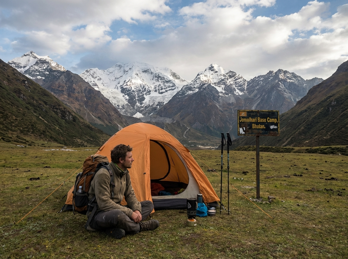
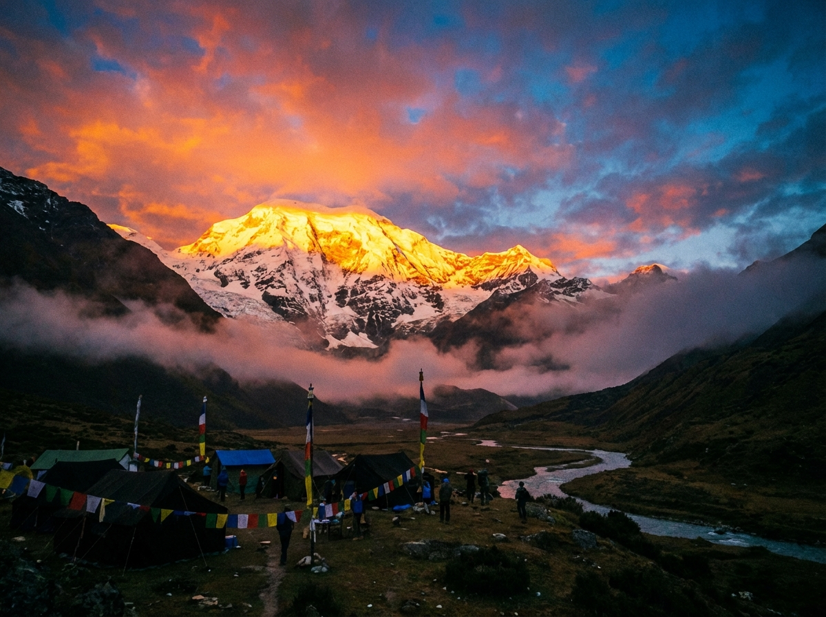
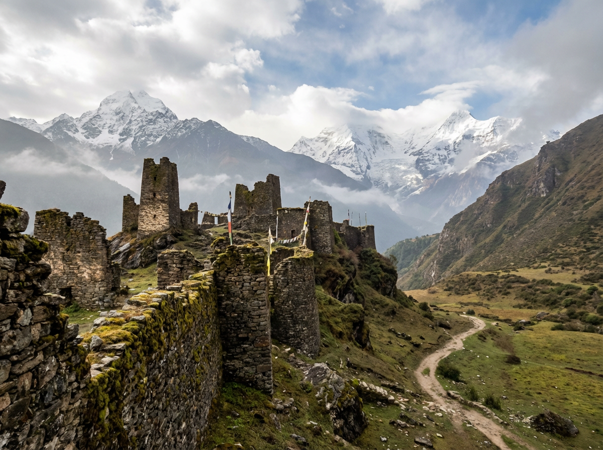
Jangothang Base Camp: The Heart of the Jomolhari Trek
Jangothang – the "land of ruins" – is more than just an overnight stop. It is the emotional center of the entire trek. Here, at 4,080 meters, the valley served in 1937 as the first base camp for the historic first ascent of Jomolhari by the British explorers F. Spencer Chapman and Pasang Dawa Lama. The ruins of an old fortress nearby gave the place its name.
Location and View
The camp lies in the heart of Jigme Dorji National Park, nestled in a vast high valley. The view of Jomolhari is overwhelming: the mighty ice wall rises directly before you, flanked by the elegant Jichu Drake. In the mornings, when the first rays of sun touch the peaks, and in the evenings when the alpenglow bathes the mountains in golden light – these moments remain unforgotten.
Day Hikes from Base Camp
The rest day at Jangothang is not just for acclimatization – it also offers the opportunity for some of the most spectacular explorations of the entire trek. Depending on fitness and interest, you have various options.
| Tour | Duration | Max. Elevation | Description |
|---|---|---|---|
| Jomolhari Glacier | 4–5 hours | approx. 4,500 m | To the foot of the glacier with close views of the ice wall |
| Jichu Drake Glacier | 3 hours | approx. 4,400 m | Shorter tour to the glacier of the neighboring peak |
| Peak Tour | 8 hours | 5,200 m | Challenging, but with spectacular 360-degree panorama |
Gear and Preparation for the Jomolhari Trek
Altitude Sickness: The Most Important Topic
Altitude sickness (Acute Mountain Sickness, AMS) is the greatest health challenge on the Jomolhari Trek. At elevations up to almost 5,000 meters, your body reacts to the reduced oxygen content in the air. Typical symptoms are headaches, nausea, dizziness, and loss of appetite. The rest day at Jangothang is therefore not optional relaxation but essential for your acclimatization.
Gear Checklist
The right gear determines your comfort and safety. Nighttime temperatures can drop to -15 °C. A high-quality sleeping bag with a comfort range of -15 °C to -20 °C is essential – you can rent one from your operator on-site if you don't own one.
Clothing
- Warm down jacket (lightweight and packable)
- Fleece mid-layer for insulation
- Waterproof, breathable outer layer (jacket and pants)
- Trekking pants (no jeans – they get cold and don't dry)
- Warm hat and gloves for cold mornings and evenings
- High-quality, broken-in trekking boots with good ankle support
Equipment
- Sleeping bag (comfort -15 °C) – rental available on-site
- Trekking poles (greatly relieve knees on long descents)
- Headlamp with spare batteries
- Sun protection: glacier glasses and SPF 50+ sunscreen
- Water bottles or hydration bladder (at least 2 liters capacity)
Health
- Personal medications in sufficient quantity
- Altitude medications like Diamox (only after medical consultation)
- Small first aid kit with blister plasters and pain relievers
- Lip balm with UV protection against intense high-altitude sun
A detailed packing list with all recommended gear can be found on our Packing List for Bhutan page.
Flora and Fauna on the Jomolhari Trek
The trek passes through Jigme Dorji National Park – with over 4,300 square kilometers, Bhutan's largest protected area. The different elevation zones support a remarkable diversity of animal and plant species, many of which occur only in the Himalayas.
Wildlife
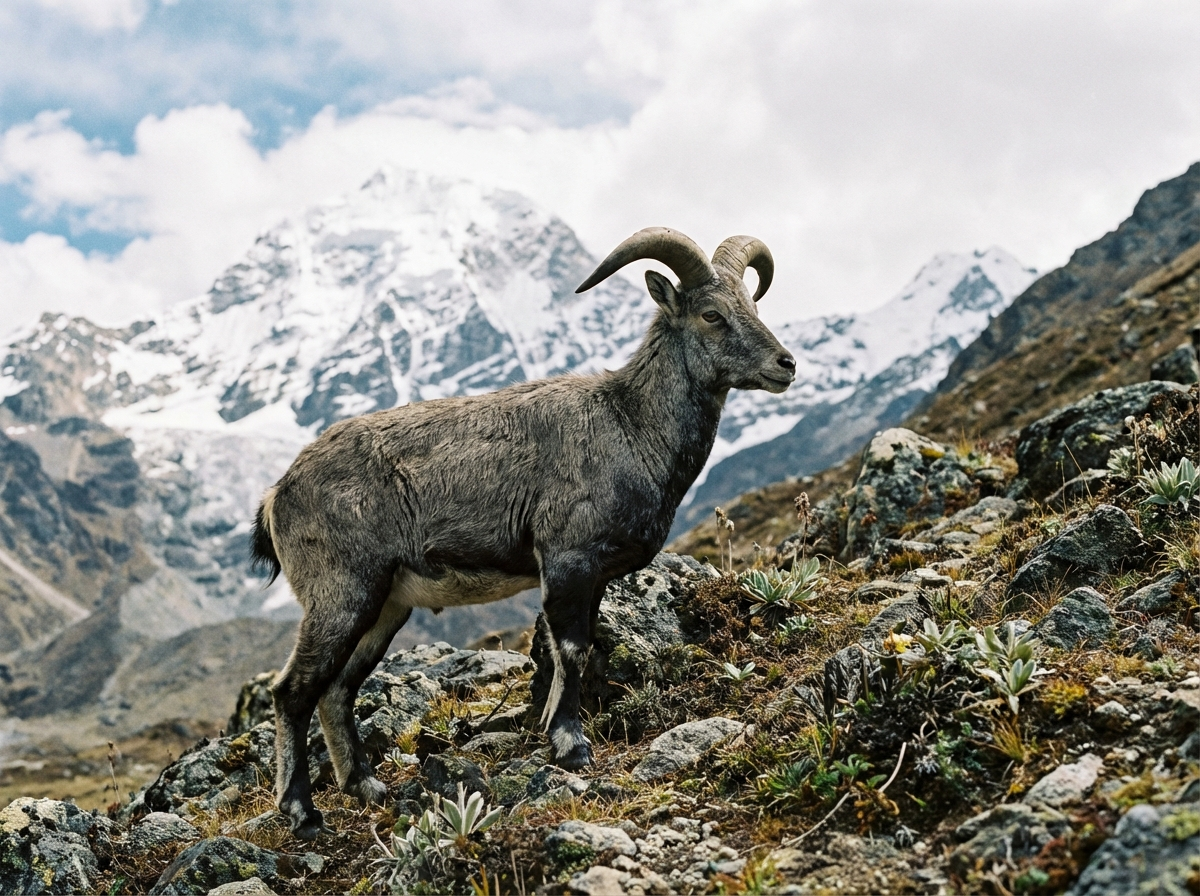
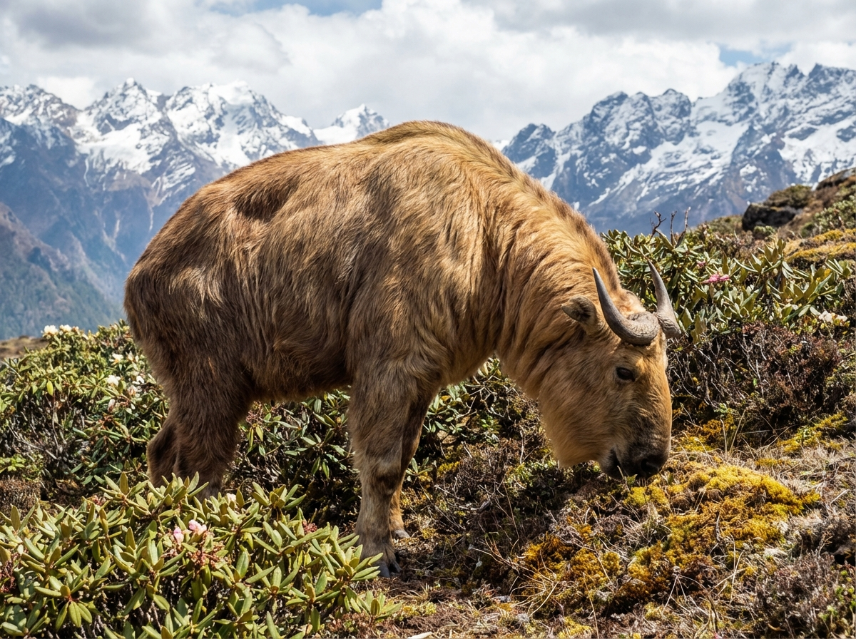
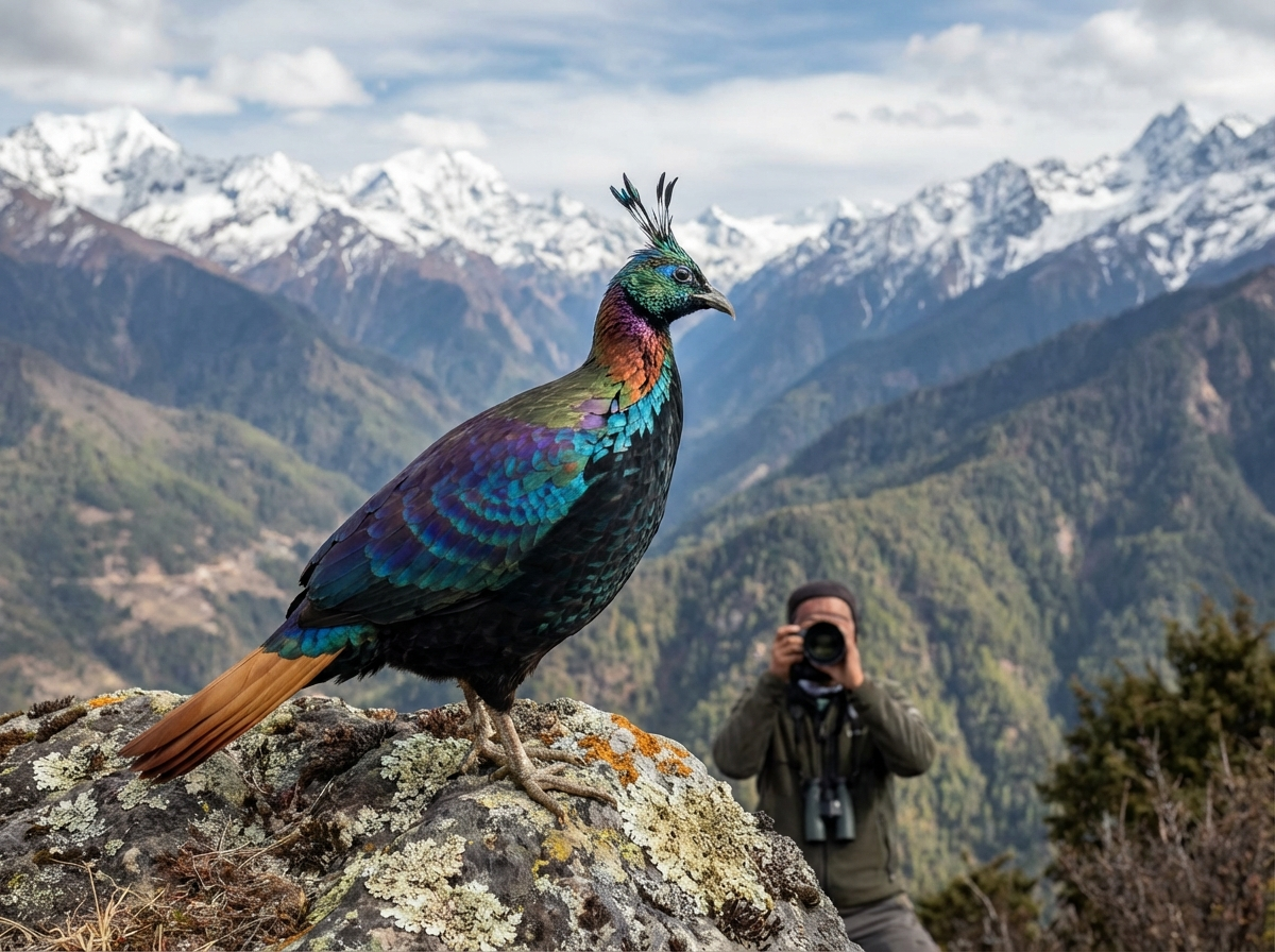
In the higher elevations above 4,000 meters, you may encounter blue sheep (Bharal), often grazing in groups on the rocks. Yaks are ubiquitous – hardy animals herded by shepherds and used to transport loads through the mountains. The shy takin, Bhutan's unique national animal with its characteristic hump and short horns, shows itself rarely. The elusive snow leopard inhabits the park but remains mostly invisible. Bird life, however, is rich and colorful: from the blood pheasant to the Himalayan monal, numerous species can be observed.
Plant Life
Vegetation changes with elevation. In the lower zones, pines, junipers, and birches dominate the forests. In spring, the hillsides transform into a sea of blooming rhododendrons – over 40 species are native to Bhutan. Further up, alpine meadows stretch, filled with wildflowers in season: gentians, edelweiss, and the blue Himalayan poppy. At the tree line, the remarkable adaptability of high-mountain flora to extreme conditions becomes evident.
Voices from Trekkers
When I stepped out of my tent in the morning and saw the Jomolhari in the first sunlight, I knew: every bead of sweat was worth it. The silence, the vastness, the proximity to this majestic mountain – an experience I will never forget. The trek was challenging, but our guide led us safely through every pass.
Frequently Asked Questions about the Jomolhari Trek
How difficult is the Jomolhari Trek really?
The trek is rated as moderate to challenging – and this assessment is realistic. It is aimed at experienced hikers with good basic fitness. The greatest challenge is the altitude: you spend multiple days above 4,000 meters, and the highest pass is nearly 5,000 meters. Prior altitude experience is helpful but not strictly required.
Do I need previous trekking experience?
Yes, we recommend experience with multi-day hikes in mountainous terrain. The Jomolhari Trek is not a beginner's tour. You should know how your body reacts to long hiking days and have experience dealing with changing weather and rugged terrain. Ideally, you have already completed hikes in the Alps or comparable mountain ranges.
Can I do the trek alone?
No, a licensed guide is required for all treks in Bhutan. This is not a disadvantage but an asset: your guide knows the route, can recognize altitude sickness symptoms early, and ensures your safety. Additionally, local guides are an invaluable source of knowledge about the land, culture, and nature.
What happens in bad weather?
Your guide decides on any route adjustments on-site. In extreme weather conditions – heavy snowfall on passes or persistent storms – the trek can be shortened or cancelled. Safety always comes first. The flexibility of the route is one reason why an experienced local guide is indispensable.
What about food on the trek?
A cook accompanies the group and prepares all meals fresh – from breakfast to dinner. The quality is surprisingly good: warm soups, rice and noodle dishes, fresh vegetables and fruit. Vegetarian diets are no problem; just mention your preferences when booking. Special dietary requirements can also be accommodated.
Is there cell phone reception on the trek?
Very limited. You may have weak reception at some camps, but don't rely on it. The trek leads through remote territory, far from cell towers. View this as an opportunity for digital detox – the mountains are more beautiful without screens.
How do I book the Jomolhari Trek?
All treks in Bhutan must be booked through a licensed tour operator. We are happy to advise you on planning and find the right route for your wishes and fitness level. For peak season in October, we recommend early booking – at least 3–6 months in advance.
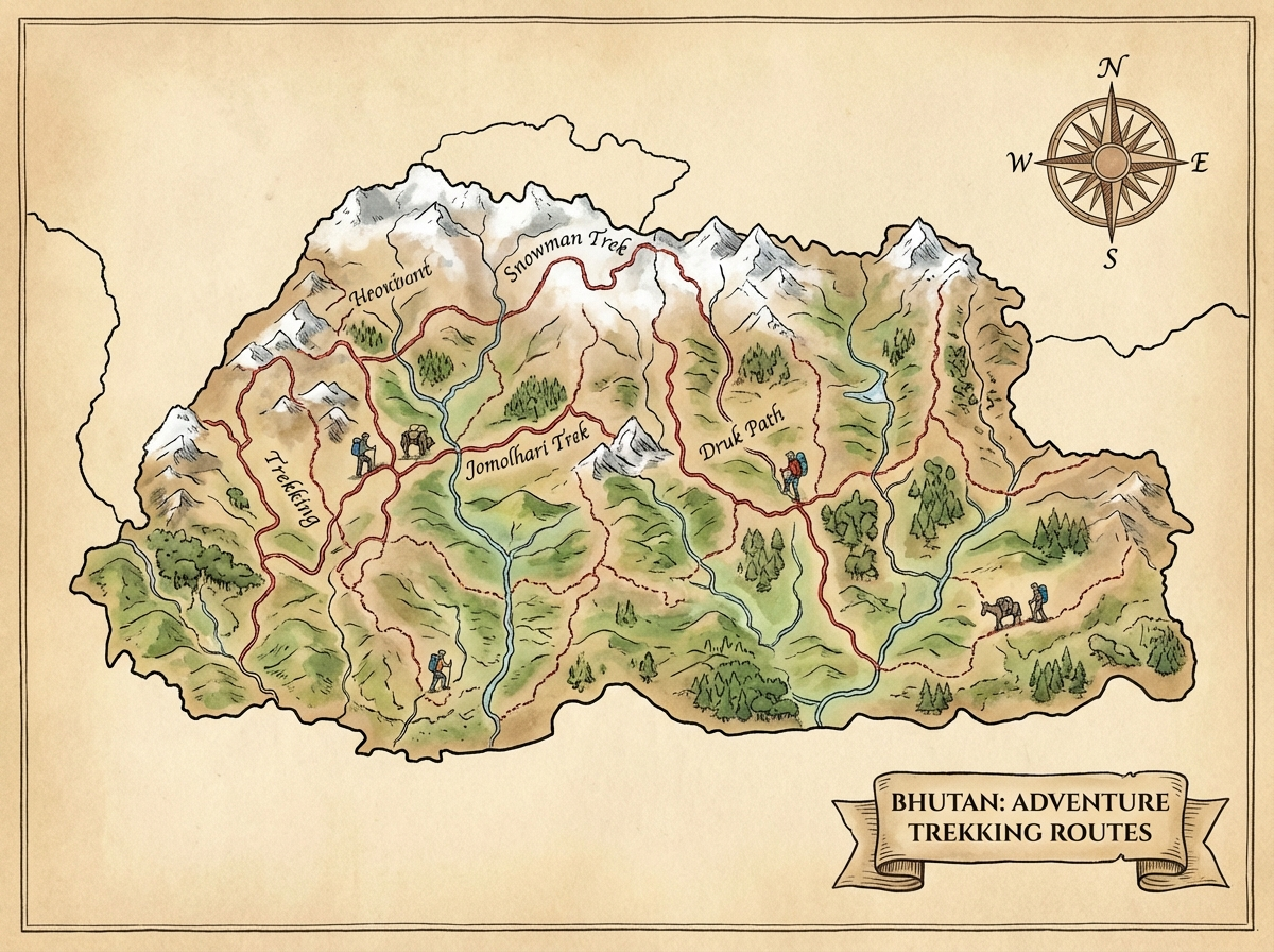
Discover More Treks in Bhutan
Jomolhari is not the only spectacular trek in Bhutan. Depending on available time and fitness, there are shorter alternatives for beginners or significantly longer expeditions for experienced mountain hikers.
 5–6 Days
 Druk Path Trek
In 5–6 days from Paro to Thimphu on a historic route. Moderate difficulty with overnight stays at alpine lakes. Ideal for your first multi-day trek in Bhutan.
 25+ Days
 Snowman Trek
25 days or more through Bhutan's most remote regions. Considered one of the world's most challenging treks. Only for very experienced and extremely fit trekkers.
 Overview
 All Treks Overview
Compare all trekking options in Bhutan by duration, difficulty, and highlights. Find the trek that's right for you.
Ready for Your Jomolhari Adventure?
We are happy to advise you on optimal planning of your Jomolhari Trek – from the best time to visit to the right variant for your fitness level. Without obligation and personal.